BLUEROCK

Projects · equipment · site context · estimates

Web Design for Excavation Contractors

Show real site work and actual capability, route residential and commercial requests, and collect documents and access context without turning a form into a site investigation, utility clearance, design, or final estimate.

Start Your Website

First-screen routing

  1. 01 · What kind of earthwork?
  2. 02 · Residential, commercial, or bid?
  3. 03 · What is known about the site?
  4. 04 · What access and records exist?
  5. 05 · Request or awarded project?

Site prep, utility trenching, septic excavation, demolition, and civil bids require different information.

Site preparation and earthwork

Route clearing, stripping, cut and fill, rough or finish grading, building pads, foundations, driveways, roads, parking, erosion or drainage scope, and material movement by plans, site context, access, quantities as known, testing, sequence, and contractor role.

Trenching and utility work

Separate water, sewer, storm, electrical, communications, gas, service, repair, directional or open-cut work only where supported, with owner or utility roles, locates, plans, depth and alignment as designed, shoring, dewatering, inspection, testing, restoration, and safety boundaries.

Septic, drainage, and water projects

Give septic excavation, tanks, drainfields, culverts, ditches, ponds, swales, stormwater, shoreline, dewatering, and other supported paths exact design, authority, environmental, access, material, disposal, restoration, and specialist boundaries.

Demolition, clearing, and commercial bids

Route structure removal, selective demolition, concrete or pavement removal, land clearing, grubbing, civil, municipal, industrial, developer, GC, and bid requests by hazardous-material exclusions, utilities, salvage, disposal, traffic, occupied operations, documents, schedule, and decision-makers.

Prove the work through projects, verified fleet access, current qualifications, and real operating territory.

Projects with real scope

Connect approved progress and completion images to project type, company role, site conditions, equipment, material movement, utilities, protection, testing or inspection only when documented, and truthful status. Do not present stock machinery or concepts as completed work.

Verified fleet and capability

List owned, leased, rented, subcontracted, or partner equipment accurately, including attachments, transport, operating limits, technology, operator or certification requirements, and availability only from current records.

Current qualifications and safety context

Publish licenses, insurance, bonding, training, safety programs, registrations, certifications, utility or authority qualifications, environmental capability, reviews, awards, and years only when verified and correctly scoped.

Real territory and project capacity

State genuine service areas, project types and sizes, material or disposal reach, mobilization and transport limits, commercial capacity, season, weather, ground, access, lead-time, bid, and emergency capability only when operations support them.

Collect site, access, utility, and document context before defining excavation scope.

  • 1Site preparation, grading, foundation or pad, trenching, utilities, septic, drainage, pond, road or driveway, clearing, demolition, civil, commercial, municipal, repair, emergency observation, or another genuinely supported project
  • 2Property and decision authority, project use, approximate work area and dimensions as known, plans or specifications, desired elevations or alignment only when designed, current surface and structures, neighboring or occupied operations, timing, budget process, and decision-makers
  • 3Observed soil, fill, rock, groundwater, drainage, vegetation, pavement, concrete, structures, debris, prior disturbance, erosion, settlement, contamination concern, or other visible context—not a geotechnical, environmental, structural, utility, or quantity conclusion
  • 4Survey, boundaries, easements, plans, specifications, geotechnical and environmental records, utility information, locate or ticket context, permits, authority correspondence, bids, addenda, schedule, inspection and testing requirements when available
  • 5Truck, trailer, equipment and crew route; road limits, gates, width, grade, overhead clearance, soft ground, bridges, staging, stockpiles, loading, import/export, disposal, washout, traffic, neighbors, landscaping, structures, water, utilities, pets, occupants, and permission
  • 6Approved photos, video, maps, drawings, records, reports, schedules, bid files, and contacts through consent, privacy, access, retention, and qualified review—not an automatic scope or authorization

Keep inquiry, site walk, investigation, estimate, award, utility coordination, mobilization, execution, and closeout distinct.

  1. 01

    Request

    The customer provides project type, authority, site and existing context, plans, access, timing, photos, records, location, and contact details.

  2. 02

    Review and qualify

    The contractor checks territory, project and role fit, capacity, documentation, safety and utility context, decision-makers, information gaps, and the supported next step.

  3. 03

    Walk and investigate

    The appropriate parties verify access, boundaries and control, visible and documented conditions, utilities, soils or environmental needs, quantities, elevations, drainage, staging, protection, disposal, testing, permits, and interfaces.

  4. 04

    Plan and estimate

    Responsible parties document assumptions, exclusions, means and methods as appropriate, equipment, materials, quantities, subcontractors, testing, traffic, protection, restoration, price, alternates, and schedule.

  5. 05

    Award and mobilize

    Scope, contract, permits, utility coordination and locates, engineering, submittals, insurance or bonding, site readiness, access, schedule, payment, and authorization are confirmed separately.

  6. 06

    Execute and close

    Mobilization, controls, excavation, discovered conditions, changes, hauling, placement, compaction or testing where required, inspections, restoration, records, demobilization, payment, and warranty handoff match actual work.

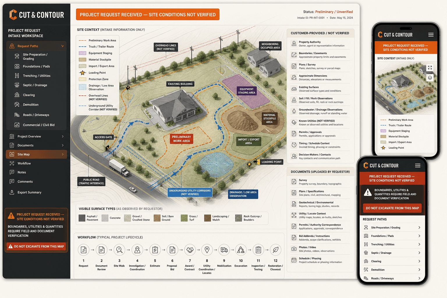
Cut and Contour fictional excavation contractor website concept with a preliminary site logistics map

Original BLUEROCK concept

Cut & Contour makes site logistics useful without making the map authoritative.

See a fictional interface for project routing, preliminary work areas, truck access, staging, material movement, observed drainage, utilities as known, documents, and an unmistakable “site conditions not verified” state.

Fictional design study—not a survey, locate, plan, clearance, real company, property, project, estimate, award, mobilization, completed work, warranty, or result.

View the concept

Excavation contractor website questions

What pages should an excavation contractor website include?

Most need a focused homepage, genuine service and project pages, accurate territory, approved work, verified fleet and qualifications, process, estimate or bid requests, and contact details. Grading, clearing, demolition, septic, utility, drainage, pond, road, civil, emergency, financing, and location pages should exist only when supported.

How should equipment be shown online?

Identify equipment and attachments accurately, including whether they are owned, leased, rented, subcontracted, or partner-provided where material. Explain relevant capability, transport, operating limits, technology, operator requirements, and supported project fit without implying that a machine alone proves availability or capacity.

Can photos produce an excavation quote?

They can help qualify a request, but final scope may depend on survey, plans, boundaries, utilities, locates, soil, rock, groundwater, contamination, access, elevations, quantities, shoring, dewatering, trucking, disposal, permits, testing, traffic, restoration, season, and schedule.

Can the website confirm underground utilities are clear?

No. Customer maps, markings, tickets, plans, or observations are context only. The contractor and responsible parties must follow the current location, notification, verification, tolerance-zone, exposure, owner, utility, and safety processes applicable to the actual project and jurisdiction.

Will an excavation website guarantee contracts or rankings?

No. It can improve technical access, project clarity, local relevance, real evidence, mobile contact, and request quality. Competition, procurement, proximity, reputation, season, weather, capacity, pricing, promotion, and follow-up also affect outcomes.
Build the website around real project capability, verified records, useful site context, and qualified estimating.

Start Your Website