Route by buyer and work type
Residential, commercial, private-road, municipal, reconstruction, overlay, repair, maintenance, and markings requests begin with different operational questions.
Fictional concept · Design study
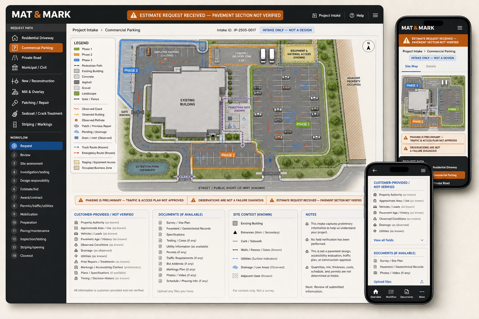
An original responsive estimate-request direction that organizes pavement areas, observed conditions, drainage, access, traffic, preliminary phasing, records, and project states before assessment.
Mat & Mark is a fictional brand created by BLUEROCK. This is not client work. The company, requester, property, site, pavement, areas, surfaces, conditions, drainage, routes, phases, markings, accessibility context, utilities, documents, interface, and states are illustrative. Nothing shown establishes a real pavement section, base, subgrade, failure cause, drainage or utility condition, dimensions, quantities, mix, thickness, accessibility compliance, design, traffic plan, price, bid, contract, award, permit, schedule, mobilization, inspection, test, opening, completed work, license, insurance, warranty, guarantee, or business outcome.
Design question
The concept makes observations, routes, occupancy, records, unknowns, and project states visible while reserving investigation, engineering, quantities, traffic planning, pricing, authorization, construction, testing, and opening for responsible workflows.
Residential, commercial, private-road, municipal, reconstruction, overlay, repair, maintenance, and markings requests begin with different operational questions.
The site plan locates preliminary work areas, surface types, observed distress, drainage, curbs, access, occupied zones, and known routes without specifying hidden construction or repair.
Truck route, equipment access, deliveries, pedestrians, emergency movement, entrances, neighbors, and three possible work phases can support review without becoming an approved traffic or phasing plan.
Cracks, potholes, rutting, patches, ponding, age, loads, and history remain customer observations—not a conclusion about pavement, base, subgrade, utilities, drainage, or failure cause.
Survey, site plan, pavement or geotechnical records, specifications, cores, testing, utilities, permits, traffic requirements, bid addenda, markings, photos, and schedule sit beside the map.
Assessment, investigation, design responsibility, estimate, award, permits, traffic and utility coordination, mobilization, preparation, paving, testing, striping, opening, and closeout remain distinct states.
Interaction architecture
Start with residential driveway, commercial parking, private road, municipal or civil, reconstruction, overlay, patching, maintenance, striping, or another supported request.
Identify surfaces, intended work areas, observed distress and drainage, access, staging, truck, pedestrian and emergency routes, occupied zones, entrances, and neighboring uses.
Record authority, approximate area and use, vehicles and loads as known, age, history, prior repairs, utilities, markings, accessibility context, documents, timing, and decision-makers as unverified inputs.
Show possible sequences and access constraints only as discussion material—not an approved traffic, accessibility, construction, schedule, or opening plan.
Confirm receipt without fabricating a verified pavement section, failure cause, quantities, materials, design, price, award, permits, start date, inspection, or completed work.
Responsible parties separately complete review, site assessment, investigation or testing, design coordination, estimate or bid, award, permits, traffic and utilities, mobilization, preparation, paving, inspection or testing, striping, opening, and closeout.
From concept to production
A production site should reflect actual territory, residential and commercial fit, materials, fleet, qualifications, assessment and testing methods, estimating, traffic and utility coordination, phasing, construction, inspection, markings, opening, maintenance, warranties, and approved project evidence.
See the BLUEROCK approach to real project evidence, useful pavement context, practical phasing, qualified assessment, and honest estimate status.
Explore Paving Contractor Web Design